Submitted by Frank Macey on
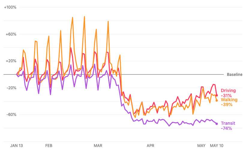
Apple has added more data to its special page titled Apple Maps Mobility Trends Reports. The tool was developed to help mitigate the spread of COVID-19. Anonymous data aggregated from Apple Maps can be displayed for hundreds of countries, states, cities, and regions. This provides insight into how people are responding to stay at home orders and reopening plans in your local area.
To access the reports, head over to apple.com/covid19/mobility and enter a place to search. Data on movement from recent weeks can be displayed on a graph, or the complete dataset can be downloaded for further analysis.

The tool shows changes in mobility from week to week, and where available details on driving, walking, and public transit are broken out for each community. The information is generated by counting the number of requests made to Apple Maps for directions.
Apple states that privacy has been baked into Maps from the beginning, so the company does not have a profile of any user's movements or searches. Random, rotating identifiers are continually reset in Apple Maps. No data in the mobility trends is associated with a user's Apple ID, and no history of where an individual has traveled is stored.
Google Community Mobility Reports offers a similar product based on its own map data. Google and Apple have also partnered on a way to provide COVID-19 contact tracing using smartphones while protecting individual user's privacy.For its part, Apple Maps recently gained COVID-19 testing sites as part of its available data. Apple has also released its own COVID-19 screening website and app, developed in conjunction with the US Centers for Disease Control. Even Siri can answer questions about coronavirus thanks to recent updates.
