Maps

iOS 6 Set to Impress With Flyover 3D Mapping

The images we've seen so far from Apple's 3D mapping software destined for iOS 6 are nothing less than stunning. AppleInsider gives us an in-depth comparison between Apple's Flyover maps and Google Street View, which provide more insight into how the new Maps app will look on the iPhone 5.
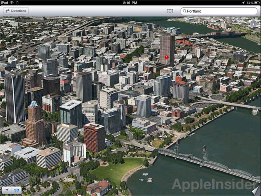
iOS 6 Flyover 3D maps

The level of detail in cities where 3D mapping and aerial photography data exist is much better in the Apple product according to screenshots. Although Google Street View lets us see everything close up from the ground level, the aerial view provided by Apple is continuous and still allows the viewer to look down individual streets for landmarks.

Google Earth Adds 3D Citites

Apple plans to replace Google Maps with its own 3D mapping software when it releases iOS 6 this fall, but Google has beaten them to the punch by adding a new 3D view to its Google Earth app.

iPhone Maps

Verison 7.0 of Google Earth features 3D imagery for 14 regions including: Los Angeles, Boston, San Francisco, Geneva and Rome. Google plans to add additional 3D cities to the iOS and Android platforms in the coming weeks. Version 7.0 also allows you to explore various locations, historic landmarks and natural wonders with its new "Tour Guide" feature. The new 3D view is available for the iPhone 4S, iPad 2 and new iPad. You can download the app for free from the Apple App Store.

Apple to to Include Yelp Check-Ins With New iOS 6 Maps App

I don't quite understand the fascination of broadcasting your whereabouts to everyone you know, but Apple is giving iPhone users the option to do so by adding a "Yelp Check-In" feature to its new mapping software. The new feature will allow users to easily share their location data without having to exit the Maps application.

iPhone Maps

The Yelp check-in option was discovered inside the Apple developer kits distributed to programmers earlier this month. Bloomberg examined the kit which included screen shots of the new feature within Apple Maps.

New iPhone iOS 6 Maps Will Have 3D Option

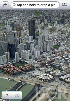
Now that iOS 6 has appeared in developer logs Apple is gearing up to show off its latest mobile operating system at WWDC next month. Rumors of iOS ditching Google Maps for an Apple-developed replacement have been around for some time. Now screenshots of impressive 3D map renderings have surfaced.

iOS 6 3D maps revealed

A new silver interface surrounds the maps app, with the location button in the lower left corner next to a 3D mode toggle. Apple's in-house mapping group is also said to be working on an improved version of traffic, and possibly even native turn-by-turn navigation for iOS 6. The upcoming sixth generation hardware is widely expected to have a larger screen, which would only improve the new maps experience.

Patents Show Major Changes Coming to Apple iOS Maps

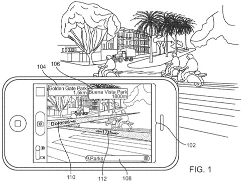
Two patents submitted by Apple point to major feature enhancements under development that would dramatically change the iOS Maps app on iPhones and other mobile devices. Both patents were discovered in the past two weeks by AppleInsider. The patent diagram below shows Apple's take on augmented reality.

Apple Maps app augmented reality

Several apps have tried to implement augmented reality by overlaying graphics on top of live video from the iPhone camera. In one example, Yelp included a feature that showed nearby businesses directly on live video of the area. The app made waves two years ago as the first iOS augmented reality application, combining data from the camera, GPS and compass.

Pages

Subscribe to RSS - Maps